Water Body Mapping in Florida
For proper pond and lake management, you need to know specific information about the body of water, such as its surface area, water volume, and depth. Muck accumulated at the bottom of your ponds and lakes adversely affects the water’s quality and can also increase the chance of flooding. When you know the water volume and depth of your body of water, you can ensure it has proper aeration to control aquatic weeds.
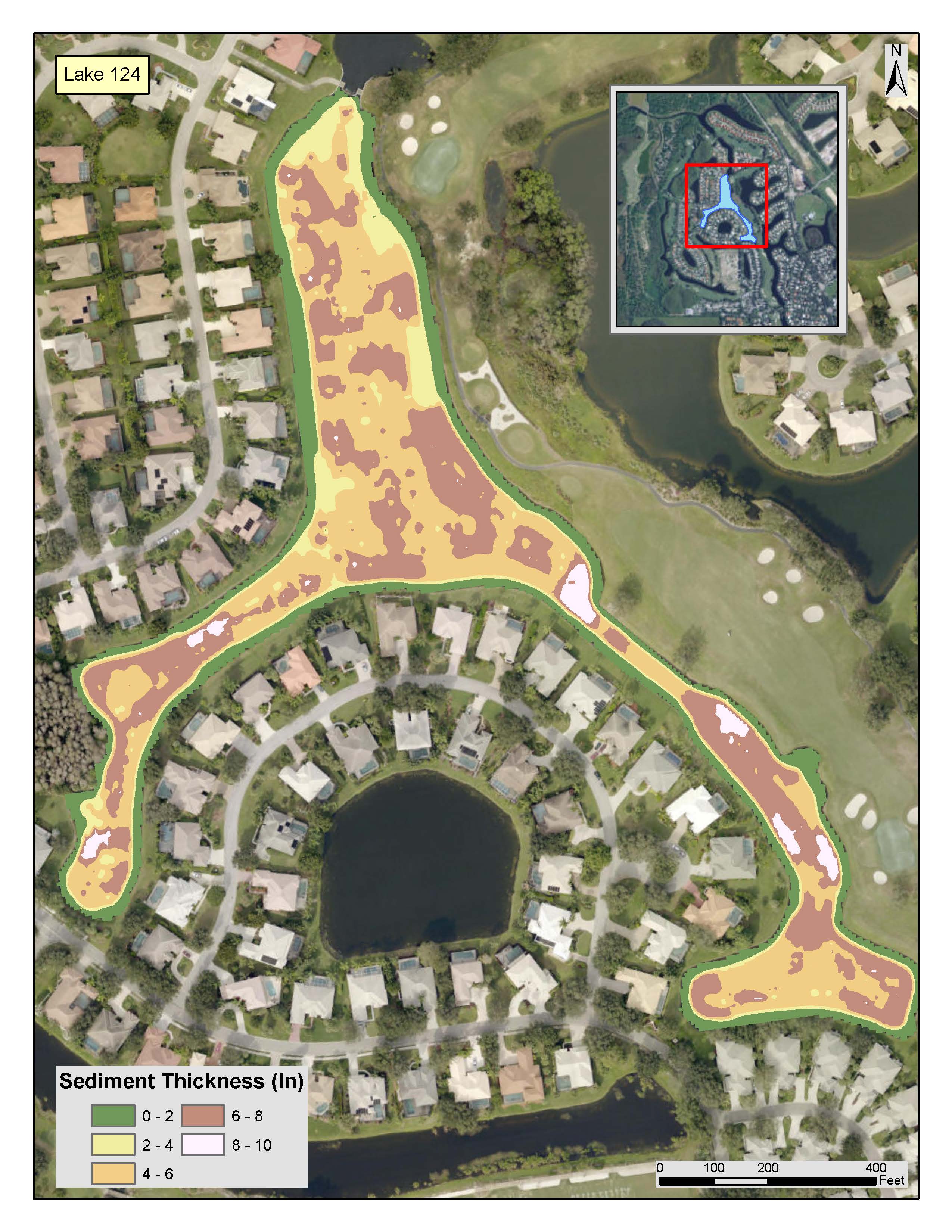
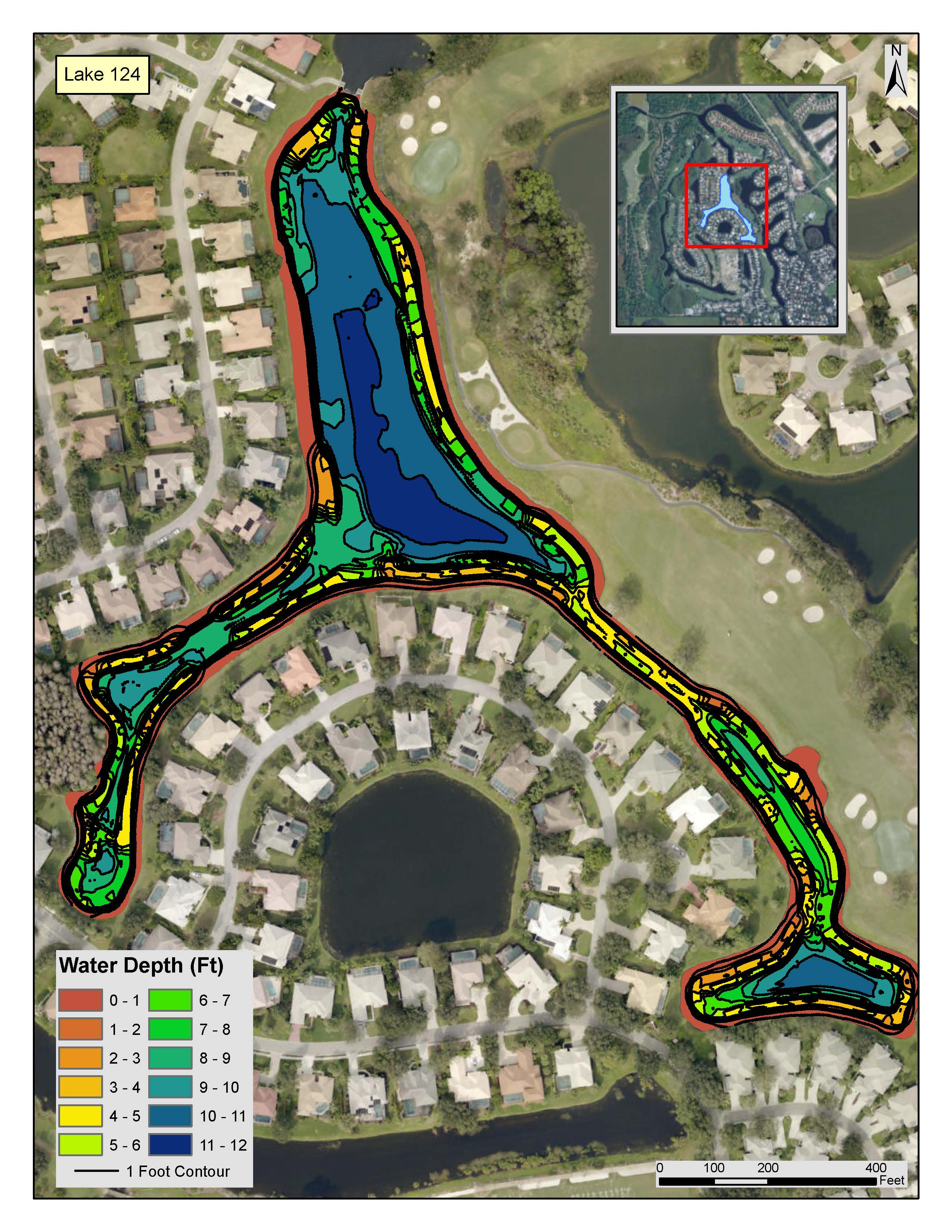
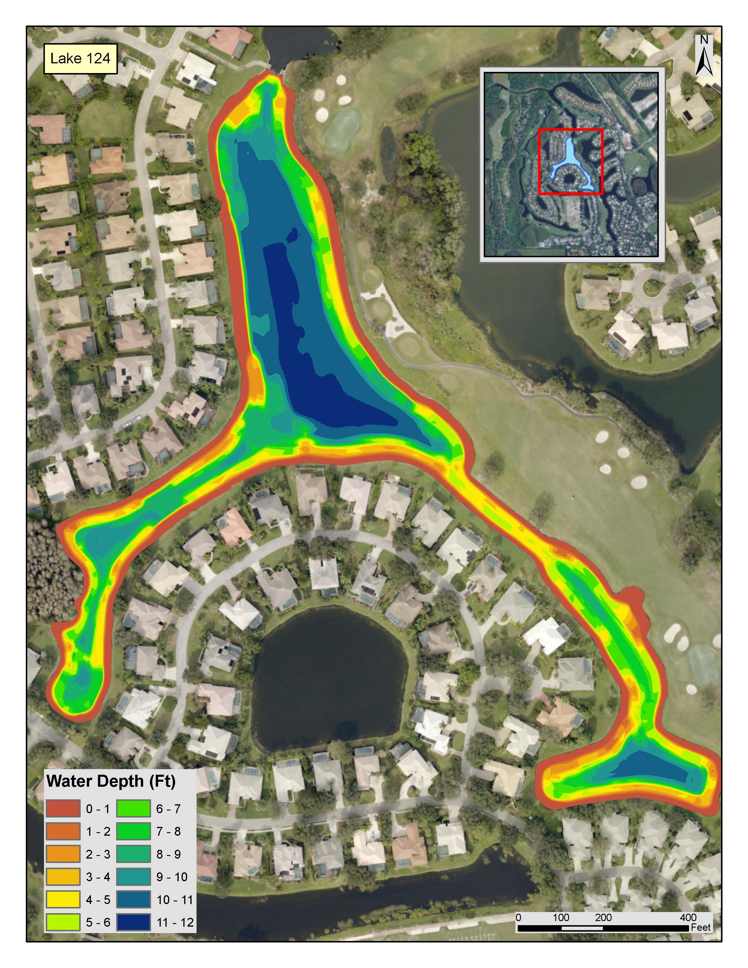
Aquagenix offers a variety of pond and lake mapping solutions for all of Florida, South Carolina, and Georgia. We use state-of-the-art equipment to help you get a complete picture of the water body’s surface area, water volume, depth, sediment thickness, and more. This valuable information is key to healthy lake management.
Read More
Get a Complete Picture of Your Pond or Lake’s Condition
We offer a suite of cutting-edge lake and pond mapping services tailored to the specific needs of our diverse clientele in Florida. Whether you’re a private homeowner or part of a commercial enterprise or government agency, we can help you capture vital information about your pond or lake to enhance your maintenance plan. Our pond and lake specialists are ready to provide essential services throughout the following areas:
- Fort Myers, FL
- Jacksonville, FL
- Orlando, FL
- Sarasota, FL
- Lauderdale, FL
- West Palm, FL
- Tampa, FL
- And more!
Lake Mapping Services
Our advanced technologies enable us to create detailed maps that offer invaluable insights into the topography, depths, and distribution of aquatic flora and fauna within Florida’s lakes. As part of our lake mapping services, we will analyze various parameters related to water quality, such as temperature, pH levels, and nutrient concentrations. This holistic approach ensures a thorough understanding of the lake’s ecological balance, enabling us to recommend targeted management strategies — including aquatic planting, vegetation removal, and erosion control — for the preservation and enhancement of the body of water.
Pond Mapping Services
If you own or manage a pond, we can provide mapping services that capture its unique characteristics — from its size and shape to the depth variations, substrate composition, and distribution of submerged vegetation within the pond. We can also perform a comprehensive water quality analysis. During this part of the pond mapping process, we will assess factors such as dissolved oxygen levels, nutrient content, and sediment accumulation to provide a comprehensive overview of the pond’s health. This data serves as the foundation for developing tailored management plans to address any issues and maintain a balanced ecosystem.
How We Map Lakes & Ponds
Our technicians use a combination of advanced technology and hands-on fieldwork to achieve a comprehensive and nuanced understanding of the body of water. Your specific lake or pond mapping solutions may include one or more of the following techniques:
Satellite Mapping
Our professionals use the most up-to-date Google Earth tools to create lake maps with key information, such as the area of the lake and perimeter measurements. This information helps you understand which management practices are best, such as herbicide treatment and organization. Having correct measurements helps lower costs and improves the efficacy of treatments. These maps often display entire lake systems with all pertinent information in a table.
GIS Mapping
In addition to satellite mapping, we use sonar mapping tools to map the entire lake bottom. The information provided, such as depth and soft bottom sediment readings, can be used to formulate treatment plans and shed light on problems, such as the presence of large amounts of algae. Once identified, these thick sediment areas can be targeted for treatment using products like live bacteria that digest the matter and improve the overall condition of the lake.
Drone Surveying and Photography
We have the ability to provide high-resolution drone video and photographs that were once only available by using an expensive airplane or helicopter service. Aerial surveying can help identify real-time problems in hard-to-reach locations, such as isolated canals, ditches, or other bodies of water that are clogged and causing stormwater systems to back up. This type of pond and lake mapping can also be used to photograph golf courses and communities in Florida for sales purposes.
The Importance of Mapping Lakes & Ponds
Understanding the topography and ecological makeup of lakes and ponds allows for targeted interventions to maintain water quality, control invasive species, and preserve biodiversity. Regular mapping also aids in the early detection of issues such as nutrient imbalances, enabling timely corrective measures to prevent the deterioration of water bodies.
Trust Our Experts for All Your Lake & Pond Management Needs
We rely on our decades of experience and state-of-the-art technology to deliver unparalleled lake and pond mapping services in Florida. Our detailed maps and analyses serve as the foundation for effective and sustainable solutions tailored to the specific requirements of each body of water. Request a quote for our lake mapping services and find out how we can help with all your management needs in Fort Myers, Jacksonville, Orlando, Sarasota, Ft. Lauderdale, West Palm, Tampa, FL, and beyond.
Would you like to speak to an Mapping Consultant?


